Hi! I'm Itzá, and I specialize in Geographic Information Science (GIS) and Remote Sensing 🌎
🌿I have an environmental and agricultural sciences background
which is why my projects revolve around this topic.
Portfolio
Who doesn't love a good visualization?
I've heard many times that "spatial data is special" and I do believe it.
Here you will find some of my projects as webinars (in Spanish), articles and web apps.
✅ Click on the images and you can further explore my work.
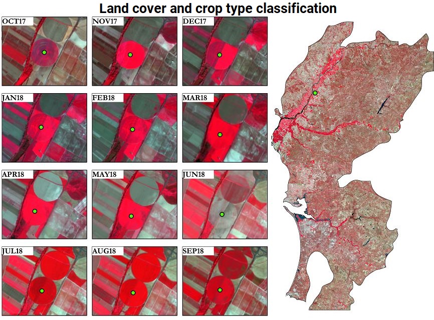
For my master thesis I developed a land cover and crop type classification project at the Portuguese national mapping agency. Please check out our publication on the ISPRS website if you're interested in Sentinel-2 time series, cloud-free mosaics, pre-processing of geospatial databases, and machine learning.
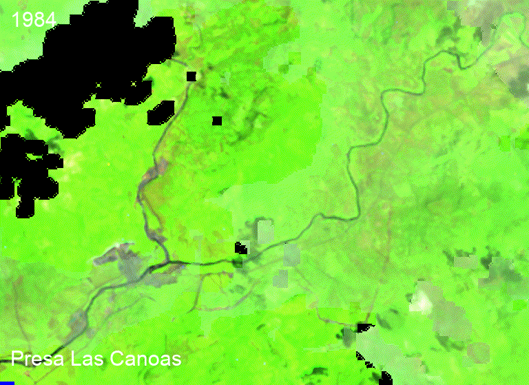
I used the geemap web app to generate this time lapse of the water reservoir Las Canoas. The gif is composed of annual Landsat images for over 30 years. This helps to identify 2 key moments: between 1985 and 1986 the reservoir was built and in 2016 there's a severe drought.
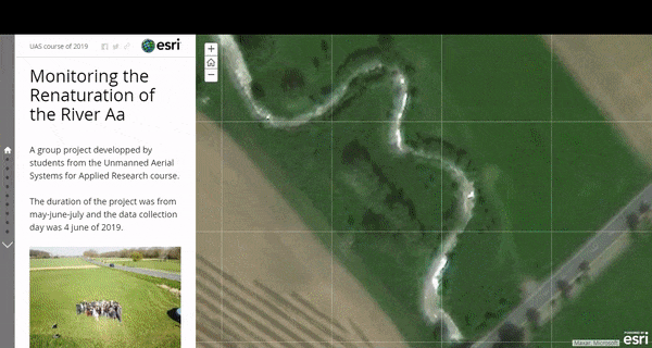
For the UAS course we flew a drone over the Aa river in Germany to monitor its renaturation process. We operated as a consulting company and worked by teams (mine was the ESRI Cloud team). We were required to upload the data to the cloud following the interoperability standards of the OGC and to create the visualization tools, such as story maps and web applications.
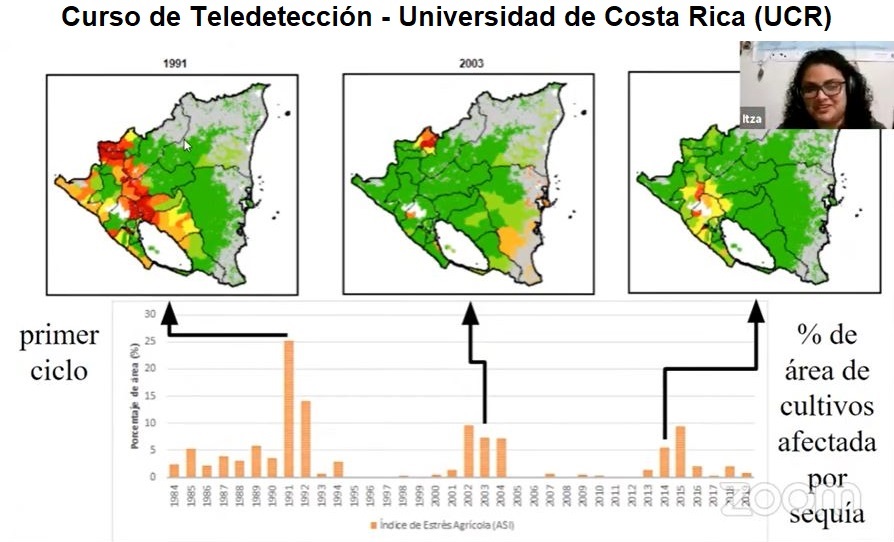
Another cool webinar in Spanish. This time as part of a remote sensing course provided by the University of Costa Rica (UCR). I talk about global monitoring systems in agriculture, my personal experience with the calibration of the Agricultural Stress Index System (ASIS) of FAO, and I redirect you to some hands-on training channels available on youtube. Check out the slides
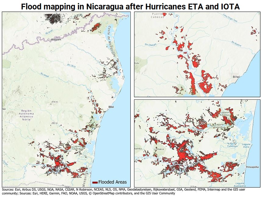
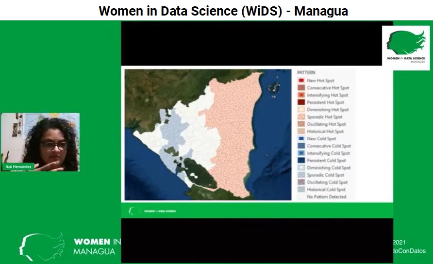
In November 2020, two hurricanes of category 4 and 5 hit Nicaragua, located in Central America. To visualize the extent of the damage, I used Sentinel-1 imagery to extract the flooded areas. Next, I created this article to link potential donators to organizations working for hurricane relief.
About Me
 I pride myself on having lots of international friends that I have met through different programs.
I grew up in Nicaragua, studied in the USA, Portugal, and Germany and taught Spanish in France.
I embrace diversity and enjoy meeting people from all over the world, who speak different languages,
come from different ethnicities, and practice (or not) distinct religious beliefs.
I pride myself on having lots of international friends that I have met through different programs.
I grew up in Nicaragua, studied in the USA, Portugal, and Germany and taught Spanish in France.
I embrace diversity and enjoy meeting people from all over the world, who speak different languages,
come from different ethnicities, and practice (or not) distinct religious beliefs.
Regarding my technical skills, I am a constant learner. Two years ago I wasn't able to create this portfolio but here we are. At the moment I focus on:
- Google Earth Engine
- ESRI: ArcGIS PRO, Online and ArcPy
- QGIS, PostGIS and PyQGIS
- GIS Programming
- Time Series: ASIS-FAO and GDAL/OGR
- Python: Numpy, Pandas, Scikit-learn and Keras
Contact
If you think we would work great together please send me a message! 🙋